We leave our vehicle at the parking lot next to the Venetian windmills and near…
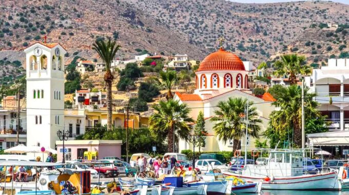
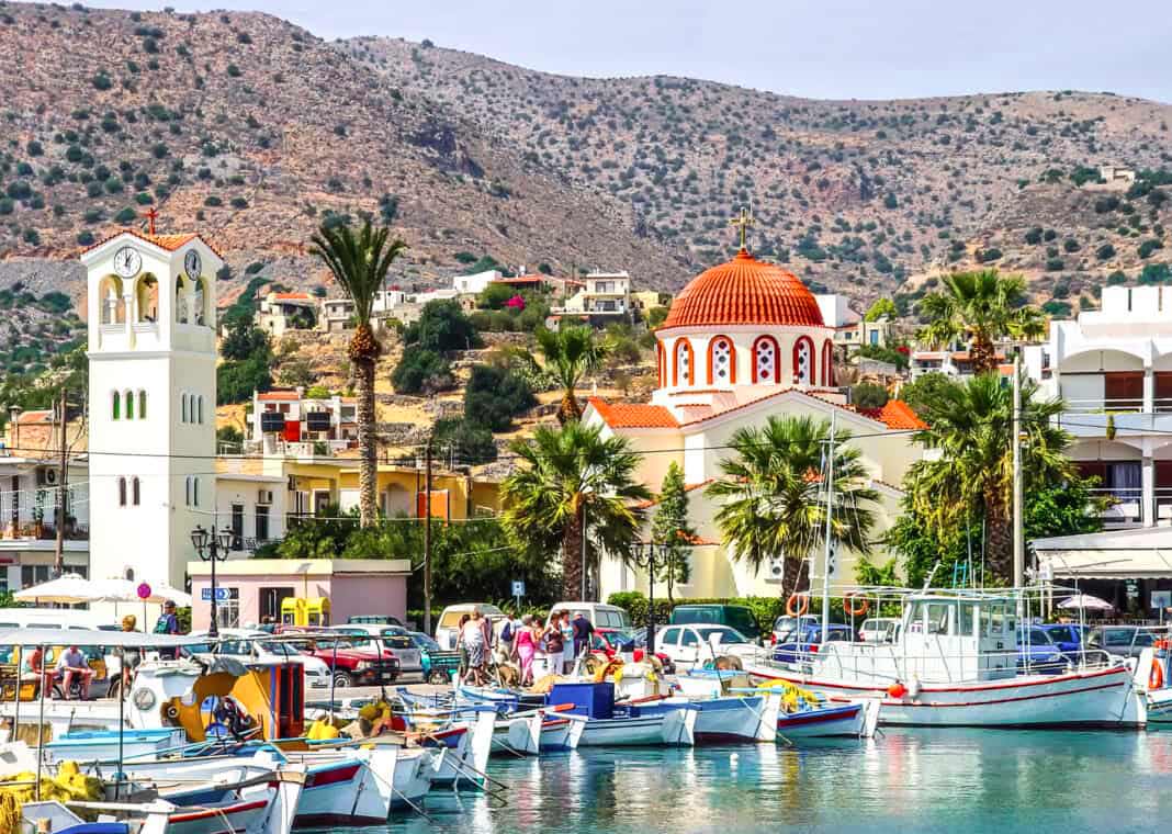
Elounda
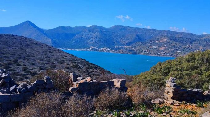
A world-famous tourist resort north of Agios Nikolaos, with lacy, windless sandy beaches, crystal clear sea, peaceful and beautiful surroundings. It is 10 kilometers far from Agios Nikolaos City and the road carved into the slope gives you the opportunity to admire the magnificent sight of the bay of Merambelo and Korfos. It is built on the southern shores of the bay of the same name, 1 km west of ancient Olousta to which it owes its name. It is the place preferred by mythical figures of Minoan Crete and historical figures of our time.
A short distance from the village is ancient Olous. The place has been inhabited in an organized manner since the Minoan years. Olous was one of the most important hundred cities of ancient Crete, with a population of over 30,000 souls. Olous’s administrative system was eunomy, a type of democracy. It had its own coins. Svoronos mentions 11 different types. Most of them depict Artemis Britomartis on one side, and Zeus the Eagle, or a Dolphin or a Star on the other. Olous’s prosperity continued during the early Byzantine period. The Basilica of Poros with its wonderful mosaic, which can be visited today, and the Basilica of Kolokytha with its exquisite white marbles bear witness to this.
Today, Elounda has 2,200 residents who live in its 6 settlements, most of them in Schisma and are mainly involved in tourism, and less in olive oil production and fishing. An event that significantly helped promote Elounda was the filming of the Disney film “Moonlight” in 1964. Since then, tourism has begun to develop slowly. Today, it has remarkable units, the majority of which are luxury, high-class hotels, which for years have been included in the 100 best hotels in the world and host important personalities of global social, economic and political life.
Facilities-Additional Info
Distance: Heraklion 67km – Sitia 75km – Agios Nikolaos 11km – Ierapetra 44km
Police Station of Elounda 28410 41348 – Regional Clinic of Elounda (Schisma) 28410 41563 – Medical emergency calling center 166 – Tourist police: 171 – Hospital Agios Nikolaos 28410 66000
Beach type: Organized Beaches next to Elounda, Sand, Fine sand, small pebbles, ideal place for snorkeling, many people at high season
Elounda is formed of seven villages :
- Agia Paraskevi – Aγία Παρασκευή
- Epano Elounda – Eπάνω Ελούντα
- Epano Pine – Eπάνω Πιναί
- Kalydon – Καλυδών (Kolokitha island area)
- Kato Elounda – Κάτω Ελούντα
- Kato Pine – Κάτω Πιναί
- Mavrikiano – Μαυρικιανό
- Schisma – Σχίσμα
Elounda: Beaches, history and culture
Surrounded by the mountain of Oxa and Mount Karfi, Elounda is practically cut off from the surrounding settlements. Due to this geographical peculiarity, its inhabitants created their own distinct culture and character over the years. The mild climate, the enchanting environment, the contact with other islands and other coastal areas, had a beneficial effect on the formation of the idiosyncrasy of the inhabitants.
The rich history of Elounda is lost in the depths of time. During the Minoan years, the area of Poros was inhabited, and specifically the famous settlement of Ancient Olous, which flourished later during the classical and pre-Byzantine era. Ancient Olous, considered one of the 100 most important cities of Ancient Crete, is located on the narrow strip of land that connects the “Nisi” peninsula with the mainland. The French created the Kanali isthmus in the period 1897-1898, facilitating sea transport and at the same time transforming the peninsula into an island.
The prosperity of Olos continued during the Byzantine period, with two important monuments testifying to this, the Early Christian Basilica in the Poros area, and the Basilica of Kolokytha, built of white marble. In the text Synekdimos by the Byzantine author Hierocles, the region of Olos is mentioned under the name Alygkos.
The Venetians built the Alykes in the second half of the 13th century and at the same time rebuilt the fortress of Spinalonga. Also during the Venetian rule, many churches were built, some of which are the Holy Trinity, the church of the Ascension, the Virgin Mary and Agios Georgios. The local population was engaged in agriculture, fishing, the processing of whetstones and the production of salt. During the period 1928-1939, the Gulf of Elounda (Korfos) was used by the British Imperial Airways as a landing and refueling station for seaplanes on their way to India.
The popular British novelist Mary Stewart lived in Elounda for about a year, writing the book “The Moon-Spinners”, which was subsequently published in the British press with great success. Walt Disney then, in 1963, adapted the work of the same name into a film, and according to the wishes of the author Mary Stewart, the filming took place in Elounda. This film was instrumental in making the village of Elounda known to business circles both in Greece and abroad. With the publicity the area had received, in 1964 Elounda was registered as a tourist area by royal decree and from 1970 its image began to change radically. The mild climate, the exceptional natural beauty, the good services are just a few of the reasons why Elounda attracts thousands of visitors every year.
The visitor can enjoy the sea by swimming in the crystal clear waters of the beaches of Elounda, which are awarded every year by the European Union with the Blue Flag.
Right next to the port is the Municipal Beach, a well-organized large beach, ideal for water sports, with taverns and cafes next to it that attracts thousands of visitors every year.
East of Schisma (the central point of Elounda), approximately 800 meters, are the blue flag-awarded beaches of Hiona and Poros.
Another beach for swimming is the beach of the Driros hotel, overgrown with tamarisks and the two pebble beaches of the settlement of Plaka with crystal clear waters. Also notable beaches are that of Agia Marina and the beach located at the edge of the settlement.
About 2 km from Elounda, on the Kolokytha peninsula, you will find the well-known homonymous beach, which although a bit short in length, in the summer becomes a real gathering place for visitors who come not only via the dirt road but also by various boats that approach the small and remote coves of Kolokytha.
Spinalonga Island is a small island located in the bay of Elounda Lagoon, on the northern side of Mirabello Bay. It covers an area of almost 85 acres and its maximum altitude is 53 meters. The island’s history continues to inspire awe – it has been a Venetian fortress, a castle town, a refuge for revolutionaries, a place of exile for lepers, and a link of communication with Cairo during the Occupation.
The island was perfectly fortified by the Venetians during their presence in Crete. Both from a construction and architectural point of view, as well as from the aesthetics of the entire landscape, the island still retains its unsurpassed beauty. Its original name was Kalydonia, but the Venetians named it Spinalonga from the Venetian word Spina-Longa, which means long thorn. According to a second, weaker interpretation, the name comes from a corruption of the phrase “in Elounda”.
Another version states that the islet took its name from a beautiful noblewoman named Loga who lived in the fortress. During the Hellenistic period or the Minoan years, the island was home to the Olunites fortress, which had been built to protect the harbor of the ancient city of Olontas. Olous was the ancient city of Elounda, which today lies submerged in the channel that connects Elounda with the Kolokytha peninsula.
In Olontas there was an important sanctuary and a great harbor. Spinalonga belonged to Olontas, which flourished until the 8th century, when fear of Arab pirates forced its inhabitants to move it away from the coast. From the 8th century until the Venetian rule, the city does not seem to have had any significant development. Spinalonga began to be fortified in 1574, when the Turks occupied Cyprus.
The Venetians, foreseeing Turkish expansion to the West, decided to build a fort on the island, which would protect the entire lagoon of Elounda. Thus, the Venetians could protect their ships in the bay of Elounda from the Turks and pirates, but also secure the lucrative salt pans of Elounda. From the salt pans they could get salt to export to Central Europe, especially having lost the salt pans that they had exploited until then in Cyprus. Thus, the Venetians built a new strong fortress on the ruins of the ancient fortress, designed according to the fortification practice of the bastion system by Genese Bressani and Latino Orsini. The first phase of construction of the fortress lasted from 1579 to 1586.
Repairs and alterations to the fortress were made before and during the Cretan War (1645-1669), while at the same time the churches of Agios Panteleimonas and Agios Georgios were built. The fortress had double rows of walls and towers, and had a total of 35 cannons. During the Cretan War (1645-1669), refugees and rebels (“chained”) took refuge in Spinalonga, who, having the islet as a base, harassed the Turks. Their action lasted as long as the Venetians occupied the fortress, since with the Treaty of Candace in 1669, Spinalonga remained under the ownership of Venice.
The Venetians tried to hold on to this strategically important fortress, as well as the fortresses of Gramvousa and Souda, hoping to recapture Crete. However, the island was surrendered to the Turks under a new treaty in 1715, putting a definitive end to Venetian dominance in the Mediterranean and their hopes. During the first centuries of Turkish rule, the fortress was marginalized and used as a place of exile and isolation.
Later, a purely Ottoman settlement gradually developed on Spinalonga, as the island provided absolute security for families. At the end of the 19th century, the role of the port of Spinalonga was upgraded as it acquired an export trade license. During the mid-19th century, a large number of residents gathered on the islet, the majority of whom were merchants and sailors, who, benefiting from the security of the fortified settlement, exploited the trade routes of the Eastern Mediterranean. It is estimated that in 1834, approximately 80 families lived in the castle town of Spinalonga, while in 1881 this number rose to 227.
Even today, there are buildings from the castle town period, such as two-story houses with high stone walls and commercial shops with large doors and windows. The life of this settlement was abruptly interrupted due to the political developments that took place in Crete during the last years of the 19th century. From 1897, French military forces were stationed on the island and for about a year on Spinalonga. The insecurity that prevailed among the Ottomans of Crete due to the revolutionary activity of the Christians forced the majority of the inhabitants of Spinalonga to emigrate. By 1903, all the Turks had abandoned the island.
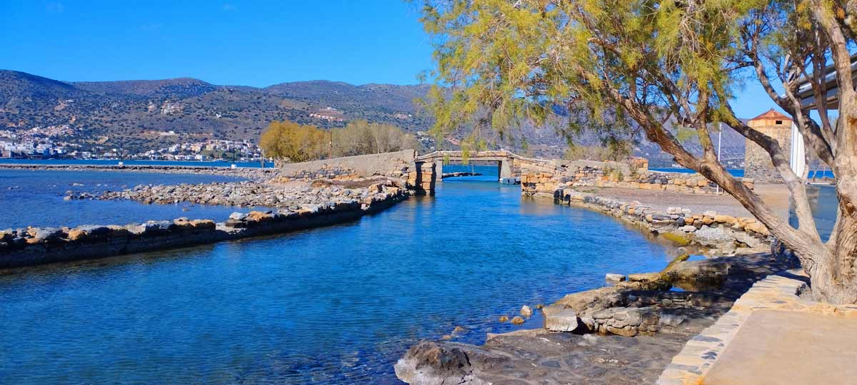
On the road leading from Elounda to the Kolokytha peninsula, at the point where the ancient city of Olous is believed to have been located, we come across the Venetian salt pans that operated until 1972. We observe dozens of tanks separated by walls in the shallow sea, where water from the Elounda lagoon was trapped from winter to April. Then, the water evaporated throughout the summer and in September the salt harvest began, which was stored in large warehouses (snows), traces of which can still be found around the lake. The Venetians built the salt pans in the 15th century with the aim of producing salt, which they exported to Europe and brought them great profit. When the Ottomans conquered Cyprus in 1570, where the Venetians were also exploiting other salt pans, the salt pans of Elounda were upgraded and larger tanks were built to cover the lost quantity. After the Ottoman conquest of Crete in 1669, the salt pans met the needs of the Turks. After the liberation of Crete, the salt of Elounda was under a Greek state monopoly and the salt pans operated until 1972. In recent years, there have been some moves to reopen them. Fishing is prohibited in the salt pan lake.
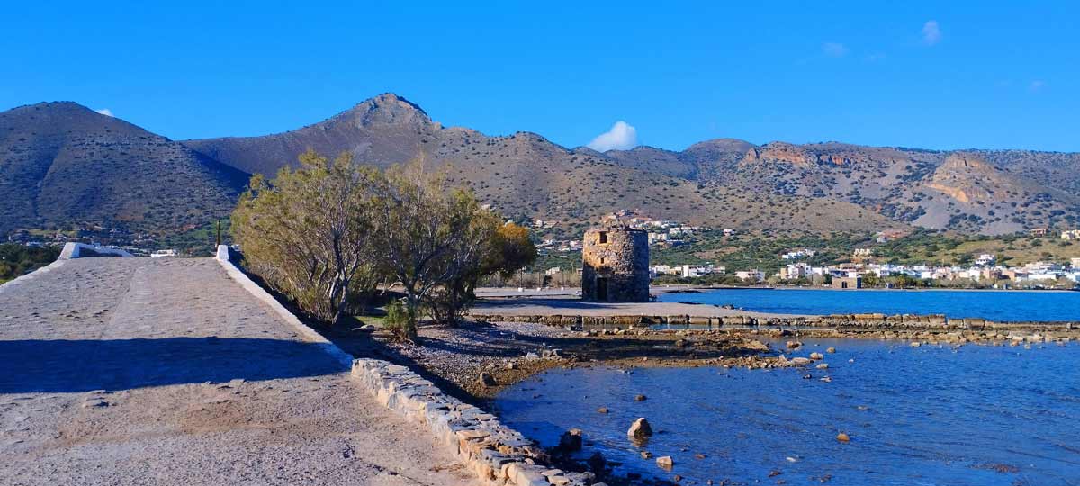 Windmills are a characteristic mainly of Eastern Crete and much more of the prefecture of Lasithi and especially of the province of Merampelo, which for the most part lacks running water. In western Crete where there were more springs and rivers, watermills developed much more. Another reason is that the prefecture of Lasithi has for the most part strong winds which favor the existence of windmills. The mills were generally built on mountain slopes and in places that were exposed to the wind so that they turned with its force. The place where they were built and there were usually many together was called mylotope (the place of the mills). Contrary to the usual building of mills on mountain slopes, in Elounda there are three windmills next to the sea, at the point where the Elounda canal is located. All of them belong to the “Xetrocharis” type, which is completely circular and turns depending on the direction of the wind.
A short distance from Elounda, in the area of Old Salt Lakes, there are few ruins of the ancient city of Olous (mainly in the sea) which was inhabited in an organized manner since the Minoan years. Olous or Olousta (otherwise Oloustas) was one of the most important hundred cities of ancient Crete, with a population of over 30,000 people. The administrative system of Oloustas was eunomy, a type of democracy. In Oloustas, Tall Zeus, Apollo and Britomartis were worshipped with a temple dedicated to her. It had its own coins. Svoronos mentions 11 different types. Most of them depict Artemis Britomartis on one side, and Zeus with an eagle, or a dolphin or a star on the other. The heyday of Oloustas continued during the first Byzantine period. This is evidenced by the Basilica of Poros with its magnificent mosaic, which can be visited today, and the Basilica of Kolokytha with its exquisite white marble.
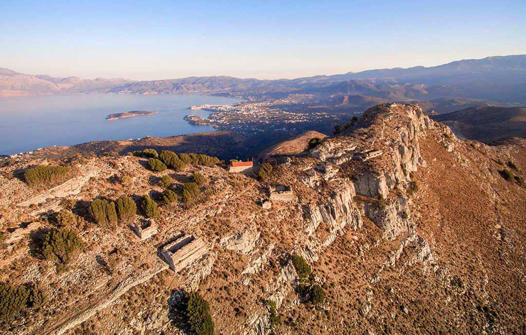
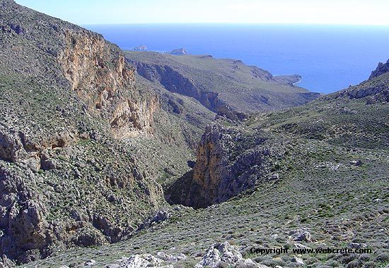
Atop Mount Oxa, at an altitude of just over 500m, a fortified acropolis is built, steep on all sides except the eastern one. The fortress in this strategic position could effectively face any enemy incursion, having control over the Gulf of Elounda and the Gulf of Merabello.
The main phase of construction of the acropolis dates back to the early Byzantine period. The surviving church, which survives with later modifications, numerous water tanks (cisterns), as well as parts of the fortification enclosure with at least three towers, dating back to the 7th and 8th centuries AD, also survive. A few remains from earlier periods also survive. The fortified acropolis of Oxa probably served as a garrison and as a refuge for the inhabitants of Olontos in the event of pirate raids. The acropolis seems to have been abandoned at the beginning of the 9th century AD, when the Arabs occupied the island of Crete.
Opposite the acropolis of Oxa, on the peak of “Karfi” at an altitude of about 540m, there are quarries of aconite, the “Naxia stone” of antiquity.
A very short distance from Elounda is the settlement of Pines, a village that, while maintaining its traditional architectural character, calms you and takes you on a journey back in time.
In ancient times, small fortresses in strategic positions protected the territory from raids and controlled the roads and passes.
One such fortress is located on the Pirgos hill west of Pines. Rectangular in shape and built with large boulders, the fortress, which dates back to Hellenistic times, belonged to the territory of Olontos and controlled the road to Driros.
On the walls of the building and on the rocks around it, male and female names, figures, as well as “traces” (footprints), associated with the garrison that was stationed there, have been carved.

The Kolokitha beach with its clear blue waters is located below the modern church of Agios Loukas, from where a short path to the sea begins. From the beach, to the north, the Byzantine church of Agios Fokas can be seen, built in honor of the Byzantine emperor Nikephoros Fokas for the liberation of Crete in 961 AD from the Arabs, which is worth walking to by the coastal path.
Access to Agios Loukas is via a dirt road that starts from the Alykes of Elounda with the windmills and passes through the Poros Canal, that is, the small canal that the French built in 1897 to allow boats to pass from the Elounda lagoon to the Mirabello Bay. Unfortunately, the beach has been very crowded in recent years due to its small size, as many tourist boats from Elounda have included it in their daily schedule, so it is best to avoid peak hours.
If you come to Kolokytha but want to be isolated, you can walk south, where there are the two small bays of Vagio with sand and stones and many tamarisk trees. Vagio does not reach the beauty of Kolokytha in any case, while in some years it collects a lot of algae. However, it is the right choice for nudists and those who want to avoid crowds, even during the tourist months. Next to the beach there are traces of a small limestone quarry

The chapel is made entirely of local stone and dominates the site with a magnificent view of the sea and the bay of Kolokytha. It is built on the site of a Byzantine church which, when it was deserted and most of its part was demolished, was converted into a sheep pen. It was rebuilt by Mr. George Charoulis who re-erected the chapel on this site.
The Early Christian Basilica of Olontos (5th century) is located in the Poros area of Elounda and was excavated in 1937 and 1960. It is a brilliant example of religious architecture of its time and is considered to have been the cathedral of ancient Olontos, the now submerged ancient city of Elounda. It belongs to the type of three-aisled wooden-roofed basilica with a semicircular apse to the east and an elongated narthex to the west. Olontos or Alyngos was probably the seat of a bishopric, as other basilicas have been identified in the vicinity.
The mosaic floor of the basilica is one of the finest surviving examples in Crete with geometric themes, representations of dolphins, peacocks and inscriptions of donors. A very important find is the inscription of the treaty of alliance between Olontia and Rhodia and an inscription from Roman times that are exhibited in the Archaeological Museum of Agios Nikolaos.
Elounda
A world-famous tourist resort north of Agios Nikolaos, with lacy, windless sandy beaches, crystal clear sea, peaceful and beautiful surroundings. It is 10 kilometers far from Agios…
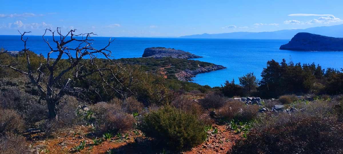
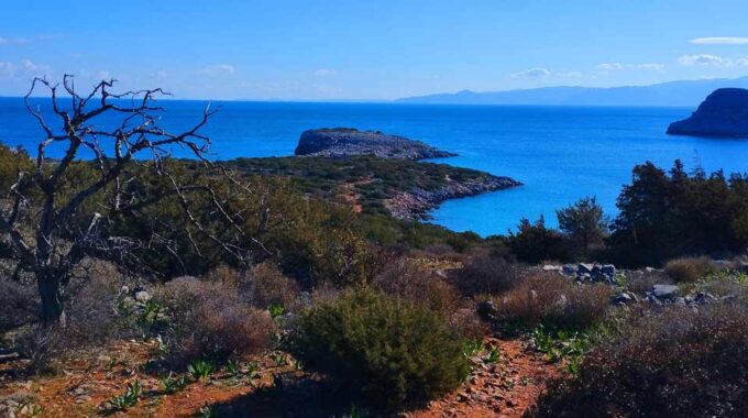
Kolokitha Peninsula, circular path
We leave our vehicle at the parking lot next to the Venetian windmills and near the bridge that connects Elounda with the Kolokytha peninsula. In the first…

The island of Kolokitha, Elounda
The island of Kolokytha or Vryonisi is located in the Gulf of Mirabello opposite the resort of Elounda. In essence, it is a peninsula that is connected…
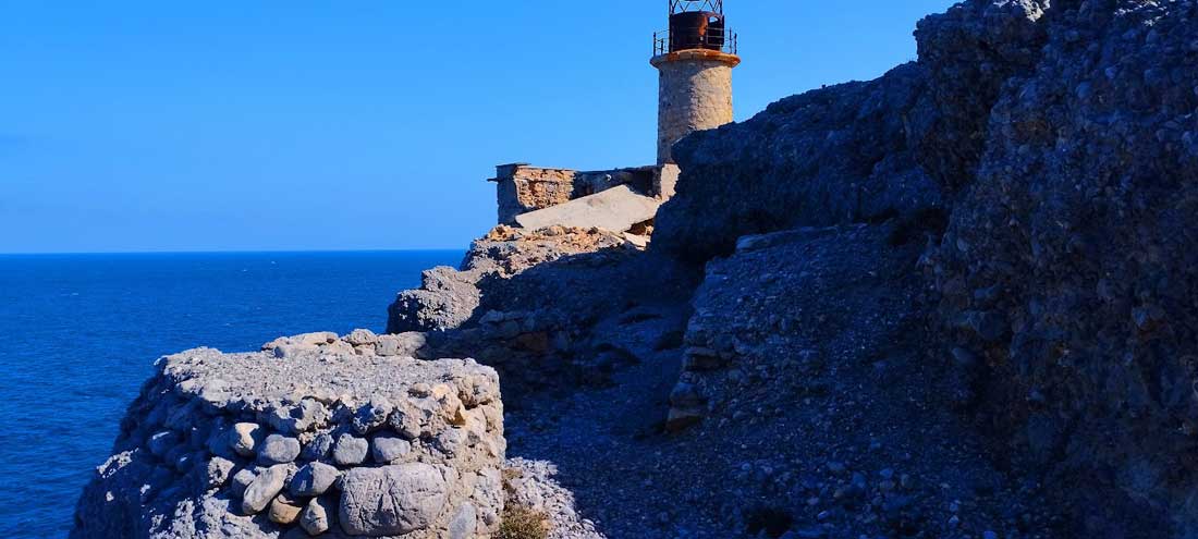
The lighthouse of Aforesmenos
The lighthouse of Aforesmenos is located 27km north of Agios Nikolaos, 20km from Elounda, and near the village of Vroucha. It was built on the cape of…
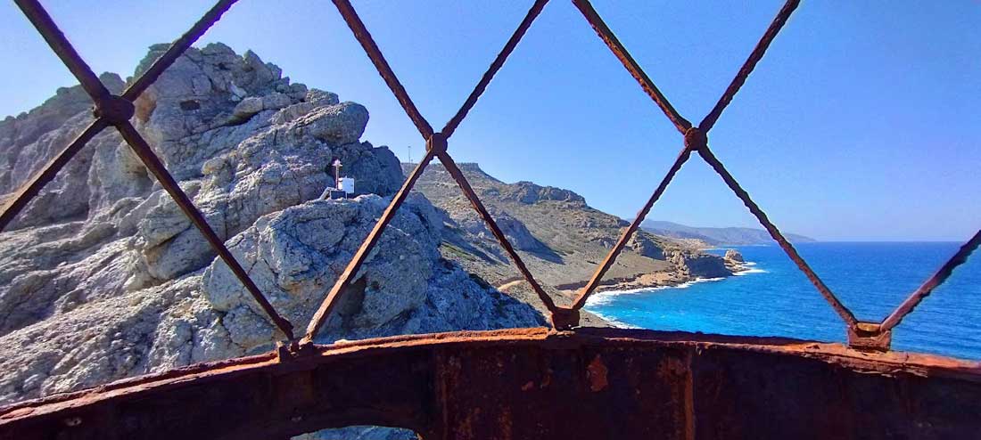
Vrouchas-Aforesmenos Lighthouse
From the village of Vrouchas we drive downhill on a narrow cement road at the beginning between cultivated fields, enjoying the impressive view of the sea. As…
Related Articles
This Post Has 0 Comments